Shaped by the staggering force of massive glaciers millions of years ago, Alaska’s Inside Passage boasts wildlife-filled fjords and lush island scenery — habitat for bald eagles, sea lions, porpoises and whales. Its mountains are carpeted with majestic forests. Inside Passage Alaska is home to Tlingit, Haida and Tsimshian Indians whose history is reflected in towering totem poles. Russian settlers left a legacy of onion-domed churches gleaming with icons.
GLACIER BAY / GUSTAVUS
Located just a few miles from park headquarters, the town of Gustavus is the jumping-off point for adventures in Glacier Bay National Park and Preserve and a charming little village of artists, fantastic gardens, wild strawberries, stunning views and even a small golf course.
ABOUT GLACIER BAY AND GUSTAVUS
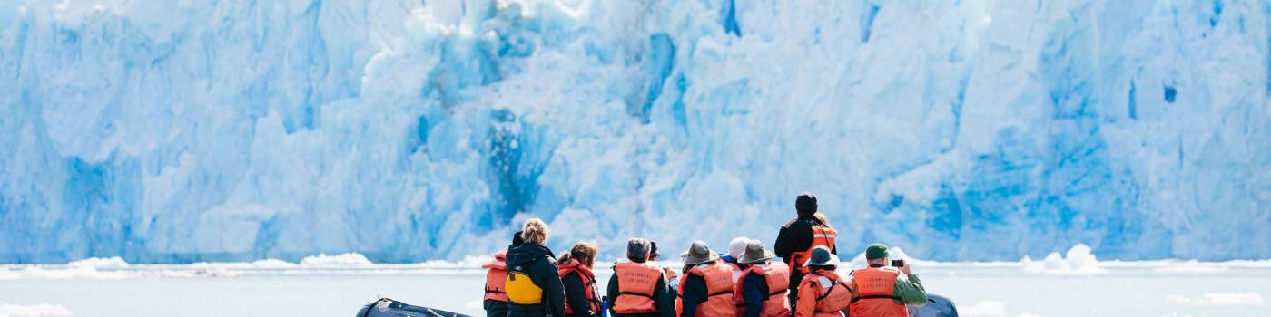
With its spectacular glaciers and abundance of marine wildlife, Glacier Bay National Park and Preserve has become the crown jewel in the itinerary of many cruise-ship and independent travelers. The bay features seven tidewater glaciers that spill out of the mountains and deposit icebergs of all shapes, sizes and shades of blue into the ocean. Of the park’s more than 300,000 annual visitors, over 90 percent visit on a cruise ship and never set foot on shore, but the independent travelers who come get the bonus of visiting nearby Gustavus as well.
THINGS TO DO
Bartlett Cove is the park headquarters and the site of a campground, a large commercial lodge, restaurant and bar and the only maintained hiking trails in the park. At Bartlett Cove, paddlers rent kayaks, visitors board tour boats for a 40-mile day cruise to see the glaciers up the bay and park rangers lead guided hikes and give naturalist programs. At the foot of the main dock is the National Park Service Visitor Information Station, where you can obtain backcountry permits, seek out information or purchase a variety of books or topographic maps that cover the park.
Gustavus is nine miles by road from Bartlett Cove. Independent travelers can take a short flight from Juneau via jet or air taxi, or hop on an Alaska Marine Highway ferry from Juneau. Like many places known for natural beauty, Gustavus boasts several acclaimed sculptors, painters, potters, jewelers and woodcarvers. You can see their work at local galleries, studios and shops in town. Beachcombing, hiking on the Nagoonberry Loop trail, biking through town or playing a round at the Mount Fairweather Golf Course are popular ways to spend the day, and a number of cozy, food-focused lodges provide a luxurious place to rest your head at night.
GLACIER BAY NATIONAL PARK AND PRESERVE
From summit to sea, Glacier Bay offers limitless opportunities for adventure and inspiration
Lofty mountain peaks, ice-sculptured fjords, an abundance of marine wildlife and, most of all, massive tidewater glaciers, have made Glacier Bay National Park and Preserve one of Alaska's most spectacular settings and a must-stop for every cruise ship sailing north through Southeast Alaska. The 3.3 million acre park is indeed an icy wilderness.
HISTORY
In 1794 a survey crew described what is now called Glacier Bay as a five-mile indent in a glacier that stretched “as far as the eye could distinguish.” In 1879 when scientist/naturalist John Muir visited the area, he found the ice had retreated more than 30 miles, creating an actual bay. The glacier has continued to recede at a rapid rate.
Glacier Bay National Park and Preserve was named a national monument in 1925. In 1980, the area became a national park and preserve, and 2.7 million acres received wilderness designation. In 1986, the park became a biosphere reserve, and the area was named a world heritage site in 1992.
ECOSYSTEM
Today, glaciers still cover 27 percent of the Park. There are more than 50 named glaciers of which seven are active tidewater glaciers that calve icebergs into the sea. Two of them, Johns Hopkins and Margerie Glaciers, are advancing. Encircling the park to the west is the Fairweather Range, the highest coastal mountains in the world at 15,000 feet.
WILDLIFE
As marine waters make up nearly one-fifth of the park, Glacier Bay is rich with marine life, including the endangered humpback whale, orcas, threatened Stellar sea lions, harbor seals, sea otters and porpoises. In addition to marine mammals, Glacier Bay is home to a large bear population, both brown and black, as well as the blue glacier bear, a rare color phase of the black. Moose, wolves, Sitka blacktail deer, mountain goats and bald eagle also thrive in the park.
ACTIVITIES
More than 90 percent of the park's visitors arrive on cruise ships, which swing through the vast bay but never stop. The rest pass through either the village of Gustavus or the park headquarters of Bartlett Cove for a variety of adventures. Most of the activities in the park are water-focused with the most popular being boat tours, kayaking, river rafting, fishing, glacier viewing and whale watching. The park's 10 miles of maintained trails is limited to Bartlett Cove but Glacier Bay offers an excellent opportunity for people who have experience on the water but not necessarily as kayakers. Kayakers are often dropped off in the well-protected arms and inlets deep in the bay where they paddle past glaciers and camp along the shoreline on their own or as part of a guided kayaking tour.
JUNEAU
Alaska’s state capital is also one of its most beautiful cities and one of the most visited communities in the state. With so much to see and do, there’s certain to be something for you in Juneau.
ABOUT JUNEAU
Downtown Juneau sits snugly between Mount Juneau, Mount Roberts and Gastineau Channel, and is a maze of narrow streets running past a mix of new structures, old storefronts and quaint houses featuring early 19th century architecture left over from the town’s early gold mining days. The waterfront bustles with cruise ships, fishing boats and floatplanes zipping in and out. With no road access to Juneau, it is the only state capital in the United States that can only be reached by airplane or boat.
THINGS TO DO
Juneau’s lively downtown is compact, easy to navigate on foot and always a favorite with visitors. Within easy walking distance of the cruise ship docks are many of Juneau’s main attractions, including the state capitol building, Saint Nicholas Russian Orthodox Church, several museums and historic South Franklin Street, where turn-of-the-century buildings today are gift shops, restaurants and pubs. Also nearby is the Juneau Convention & Visitors Bureau with visitor information, displays and walking tour maps of the city.
Just a short drive from downtown, one of the city’s most iconic sites sits at the edge of a residential neighborhood: Mendenhall Glacier. The glacier sits within the Tongass National Forest – the largest national forest in the United States – and visitors to the area can watch icebergs calve off its frozen face into Mendenhall Lake, go for a hike or check out the Mendenhall Glacier Visitor Center. Mendenhall Glacier is one of the 38 major glaciers that extend from the 1,500-square-mile Juneau Icefield, and many of them can be seen from the air as part of a flightseeing tour. Most helicopter tours offer glacier landings, glacier treks and glacier dog sled rides.
Whale watching tours are a popular way to see the diverse marine life in the area including Steller sea lions, Dall’s porpoise, killer whales and humpback whales, which return to the area each summer to feed on krill and herring. Juneau has about 60 humpbacks that frequent the area and are so commonly viewed that many tour operators offer a guaranteed sighting or your money back.
For many, the best way to experience the area is the most affordable — on foot. Few cities in Alaska or elsewhere offer as many hiking trails as Juneau. Many wind to the face of a glacier or climb above the tree line, where you can overnight in a public-use cabin.
Juneau also offers access to some of the region’s top attractions, including Glacier Bay National Park and Preserve, Tracy Arm-Fords Terror Wilderness Area and Admiralty Island National Monument.
GETTING HERE AND AROUND
Most summer visitors reach Juneau via cruise ship – indeed, it is one of the most popular ports of call in Alaska. However, Juneau is also served multiple times a day by Alaska Airlines, and can be reached by the state’s ferry system, the Alaska Marine Highway.
HISTORY
One of the reasons Juneau has so much character is that it’s one of Alaska’s oldest cities. Established before the big Klondike Gold Rush of 1898, Juneau also has gold in its past. In 1880, a local Tlingit Indian chief led prospectors Joe Juneau and Richard Harris to what later became known as Gold Creek, where the two men discovered nuggets just laying on the ground. Soon after a town site was established, making Juneau the first city founded after the purchase of Alaska by the United States from Russia. The area later became home to what was at the time the largest hard-rock gold mine in the world – the Treadwell Mine. Juneau became Alaska’s territorial capital in 1906, and, after statehood in 1959, its state capital.
SKAGWAY
A colorful history, scant rain and a lot of cruise ships makes a Skagway one of the most interesting and popular towns to visit in the Inside Passage.
ABOUT SKAGWAY
Skagway rarely disappoints visitors. A seven-block corridor along Broadway features historic false-front shops and restaurants, wooden sidewalks, locals in period costumes and restored buildings, many of which are part of the National Park Service-managed Klondike Gold Rush National Historical Park. Beginning in 1897, Skagway and the nearby ghost town of Dyea was the starting place for more than 40,000 gold-rush stampeders who headed to the Yukon primarily by way of the Chilkoot Trail.
Today Skagway survives almost entirely on tourism, as bus tours and more than 400 cruise ships a year turn this small town into a boomtown again every summer. Up to five ships a day stop here and, on the busiest days, more than 8,000 visitors — 10 times the town's resident population — march off the ships and turn Broadway Avenue into a modern-day version of the Klondike Gold Rush.
THINGS TO DO
Five times a day during the summer, National Park Service rangers lead a free, 45-minute walking tour of the historic district, stopping at historic buildings like the Mascot Saloon Museum, the first cabin built in Skagway and one of the town’s earliest brothels.
For the adventurous, Skagway has an excellent trail system that begins just blocks from the downtown area and allows hikers to trek to alpine lakes, waterfalls, even the graves of Skagway’s most notorious residents, Soapy Smith and Frank Reid. The town also serves as the departure point for one of Alaska’s most popular backpacking adventures: the Chilkoot Trail, a three- to four-day hike along the same route that the stampeders followed on their way to the Klondike Gold Fields in Canada to the north. For more information on the Chilkoot Trail and hiking in Skagway contact the Klondike Gold Rush National Historical Park Visitor Center.
The historic White Pass & Yukon Route railroad provides tours to the top of the mountain pass north of town. Seated in parlor cars, passengers ride up the most spectacular part of the trip viewing scenery such as Glacier Gorge, Dead Horse Gulch and Bridal Veil Falls. At the top they see the White Pass at 2,885 feet, which is also the international boundary between the United States and Canada.
SITKA
Sitka is the only Inside Passage community that fronts the Pacific Ocean, hugging Baranof Island's west shore in the shadow of the impressive Mount Edgecumbe, a dormant volcano with a graceful cone reminiscent of Japan's Mount Fuji.
ABOUT SITKA
Located on Sitka Sound, the city of about 9,000 residents is marked by the picturesque remnants of its Russian heritage, including the onion-shaped domes and gold colored crosses of the beloved Saint Michael's Russian Orthodox Cathedral. The city and borough limits include most of Baranof Island, where the city of Sitka is located, along with south Chichagof Island and many other small, forested islands along the coast.
Although first inhabited by Native Tlingit Indians, Sitka is recognized as the heart of the Russian influence in Alaska. The Russians arrived by 1741 and in 1804 attacked a Tlingit fort. The region’s most famous battle eventually led to the creation of Sitka National Historical Park. Originally established as New Archangel, Sitka became the capital of Russian American in 1808. When Russia sold Alaska to the United States on October 18, 1867, the transfer ceremony took place on Sitka’s Castle Hill.
THINGS TO DO
Pick up a map from the Visitor’s Center in Harrigan Centennial Hall offering several walking tours that highlight the city’s history and culture including the Russian Blockhouse, Russian Bishop's House, Princess Maksoutoff’s Grave and Castle Hill to name a few, that date back to the Russian era. There are 22 buildings in Sitka on the National Register of Historic Places, so there’s plenty to see on a walk through town. Downtown features numerous art galleries, a fine bookstore and gift shops, while the city’s main event during the summer is the Sitka Summer Music Festival.
Centennial Hall, the community’s civic and convention center, is also the venue for the spirited New Archangel Dancers, who perform Russian folk dances using authentic music, choreography and costumes. Sitka National Historical Park features a remarkable collection of totem poles carved by Tlingit and Haida artists that are placed along a well-maintained trail in the forest. Near the park is Sheldon Jackson Museum, one of two official Alaska State Museums. The museum's impressive collection represents many different Alaska Native cultures.
Sitka offers superb hiking with trails that begin in the lush rainforest that surrounds the city and often end up high in the mountains. The Tongass National Forest can provide information and maps to more area trails for hiking and camping information.
For the nature lover, Sitka is home to a number of attractions that will amaze and educate visitors. These wildlife-oriented destinations include the Alaska Raptor Center and Fortress of the Bear. The Alaska Raptor Center rehabilitates injured birds and releases them back into the wild. The few who don’t regain flight remain housed at the center and visible to guests. Fortress of the Bear features a three-quarter-acre habitat for orphaned brown bear cubs complete with covered viewing areas.
HOONAH/ICY STRAIT POINT
Nestled against the base of White Alice Mountain, Hoonah is the largest Tlingit village in Alaska.
ABOUT HOONAH
The town of Hoonah is located on Chichagof Island, about 30 miles west of Juneau along Icy Strait in the Inside Passage. The Huna, a Tlingit tribe, have lived in the Icy Strait area for thousands of years. In 1912, the Hoonah Packing Co. built a large salmon cannery north of town. The cannery operated on and off under different ownership until the early 1950s, and it sat shuttered for decades until the local Native corporation, Huna Totem Corp., purchased and rehabilitated the facility to create the private cruise port now called Icy Strait Point.
THINGS TO DO
Since Icy Strait Point opened in 2004, Hoonah has attracted more visitors, particularly those who arrive by cruise ships. The port is centered on the restored salmon cannery, which now houses a museum, local arts and crafts shops, restaurants and a mid-1930's cannery line display. Outside is the world’s largest and highest zip line at 5,330 feet long, featuring a 1,300-foot vertical drop. Icy Strait Point offers a range of excursions for visitors, from Native dance performances to bear viewing and whale watching.
Hoonah’s access to the outstanding fishing along Icy Strait also attracts sport fishing and wildlife enthusiasts. Whale watching is considered excellent near Hoonah and humpback and killer whales are often spotted along the shores right in front of town. Sea kayakers are also drawn here for the 40-mile wilderness paddle that follows the shorelines of Port Frederick and Tenakee Inlet from Hoonah to Tenakee Springs. The two inlets are connected by a short portage and the trip ends for many in the Tenakee Springs’ natural hot springs. For more information on sea kayaking and hiking in the area, contact the Tongass National Forest, which manages the wilderness areas around Hoonah.
HAINES
Located 75 miles north of Juneau, Haines is one of the Inside Passage’s most scenic communities and a crucial link between the roadless communities of the Inside Passage to the Alaska Highway.
ABOUT HAINES
Every summer, thousands of travelers, particularly RVers, pass through Haines on their way to Canada’s Yukon and Interior Alaska. Haines sits at the northern end of the Inside Passage and is an important port of call for the Alaska Marine Highway System, whose ferries deposit RVers and other travelers in Haines en route to the Alaska Highway to the north. It is one of the few communities in the region that is connected by road to Canada and the Alaska Highway. In 2009 the Haines Highway, which follows the Chilkat River Valley 40 miles to the Canadian Border, was designated the Valley of the Eagles National Scenic Byway for the annual fall migration of bald eagles to the area. Although Haines sees its fair share of vehicle traffic, it retains the charm and character of small-town Alaska.
Like its sister community of Skagway, Haines was established during the Klondike Gold Rush, when the entrepreneurial Jack Dalton capitalized on an existing Tlingit trade route and turned it into a toll road leading to the riches of the Klondike gold fields. The Dalton Trail quickly became such a heavily used pack route to mining districts north of Whitehorse, Yukon that the U.S. Army arrived in 1903 and established Fort William H. Seward, Alaska's first permanent post.
THINGS TO DO
Interesting museums, a thriving arts community, campgrounds located within walking distance of downtown and restaurants that are not part national chains all offer compelling reasons to say a while in Haines. It is one of the sunniest spots in the notoriously rainy Inside Passage region, and its stunning mountain-and-ocean landscape offers hiking, kayaking, fishing, whale watching and plenty of other outdoor-adventure options.
Haines isn’t just a favorite with humans – late each fall, thousands of bald eagles congregate at the Chilkat River to feast on a late run of salmon. The gathering inspired what is now a well-established annual event called the Alaska Bald Eagle Festival, which, along with birdwatching, features photography workshops, art shows and preservation-focused lectures. Nothing compares to the sight of eagles too numerous to count clustered in the branches of trees lining the river, swooping in to snatch salmon from the river’s icy waters.
Shops, bed-and-breakfasts and artist galleries now fill Fort Seward and provide a historical shopping district for visitors.
Also not to be missed is the world’s only museum dedicated to the hammer. The Hammer Museum is a true labor of love showcasing the owner’s admiration for mankind’s oldest implement.
CHILKAT BALD EAGLE PRESERVE
It's a remarkable sight - hundreds of birds sitting in the bare trees lining the river, often six or more birds to a branch. Every portion of this preserve is used by eagles at some time during the year, and through the months of October to February, more than 3000 eagles congregate here to feed on spawning chum salmon.
HISTORY
The Alaska Chilkat Bald Eagle Preserve was created in 1982 when the state reserved 48,000 acres along the Chilkat, Klehini and Tsirku Rivers to protect the largest known gathering of bald eagles in the world. It also sustains and protects the natural salmon runs and allows for traditional uses; provided such uses do not adversely affect preserve resources.
ECOSYSTEM
The river "flats" of the Chilkat River along the Haines Highway between miles 18 and 24 are the main viewing area for eagle watchers and considered critical habitat in the preserve. Bald eagles are attracted to the area by the availability of spawned-out salmon and open waters in late fall and winter.
WILDLIFE
Even during the summer the preserve is one of the best places to see an eagle in Southeast Alaska. The Chilkat Valley is the year-round home for between 200 and 400 eagles and more than 80 eagle nests have been observed in the preserve itself. By the time the fall migration begins in October, the resident eagles are through raising their young but immature eagles will often stay nearby for a year or more.
Five species of salmon spawn in these and other nearby streams and tributaries. The salmon runs begin in the summer and continue on through late fall or early winter. The salmon die shortly after spawning and it is their carcasses which provide large quantities of food for the eagles. This combination of open water and large amounts of food bring large concentrations of eagles into the Chilkat Valley beginning by early October and lasting through February.
ACTIVITIES
The best time to be in Haines for the fall migration is the second week of November when the town stages its Alaska Bald Eagle Festival. The event attracts hundreds of visitors from around the country to Haines for five days of speakers, presentations and special exhibits at the Sheldon Museum and the American Bald Eagle Foundation Center. The most popular activity at the festival is trooping out to the Chilkat River on 'expedition buses' with noted naturalists onboard and viewing more eagles than anywhere else in the country at anytime of the year.
KLONDIKE GOLD RUSH NATIONAL HISTORICAL PARK
Experience the golden history of the last grand adventure of the 19th century
The glacially-carved valleys, stream channels, snow pack and stunning views that make up Klondike Gold Rush National Historical Park's physical landscape provide a compelling stage for its gold rush story. Commemorating the Gold Rush of 1897-98, this 13,191-acre park encompasses a six-block historical district in the town of Skagway, the nearby ghost town of Dyea and the famous Chilkoot and White Pass Trails.
HISTORY
The park commemorates the Klondike Gold Rush of 1897 – 1898. When gold was discovered in 1896 in Bonanza Creek, near Dawson City in the Yukon Territory, Skagway and Dyea became the starting places for more than 40,000 gold-rush stampeders making their way to Canada’s Yukon goldfields by way of the Chilkoot Trail. The miners were required to have a year’s worth of supplies, causing them to make several trips over the rugged, 33-mile trail. The actual stampede lasted only a few years, but it produced one of the most colorful periods in Alaskan history.
It was a lawless frontier town controlled by villainous 'Soapy' Smith, who was finally removed from power in a gunfight by town hero Frank Reid. At the height of the gold rush, Michael J. Heney, an Irish contractor, convinced a group of English investors that he could build a railroad over the White Pass Trail to Whitehorse. Built with little more than gun powder and picks, the White Pass & Yukon Route climbs from sea level to 2,865-foot White Pass in just 20 miles, making it one the world's steepest train routes.
The downtown Skagway Historic District became a national landmark in 1962 and joined the national register in 1966. The Klondike Gold Rush National Historical Park joined the national register in 1976, and the Chilkoot Trail became a national landmark in 1978. The park was designated as an international historical park by presidential proclamation in 1998.
ACTIVITIES
Today Klondike Gold Rush National Historical Park is a cruise ship favorite making it the most popular park in Alaska with 850,000 visitors annually. The park offers a unique balance of history and outdoor adventure. The streets of Skagway are lined with dozens of historic stores, saloons and public buildings of which the National Park Service has restored fifteen. In neighboring Dyea, the park interprets how a town, once the size of Skagway, disappeared in the years following the Rush, though it still serves as the starting point for hikes on the famous, 33-mile Chilkoot Trail, the most popular backpacking route in Alaska. Other outdoor activities include camping, rafting, wildlife viewing, hiking, fishing and historic walking tours.
MENDENHALL WETLANDS STATE GAME REFUGE
Mendenhall Wetlands State Game Refuge is where land and and sea meet and intermingle in saltwater wetlands. The refuge consists of 4,000 acres stretching 9 miles along the shores of Gastineau Channel between downtown Juneau and its airport, and provides a vital feeding and resting area for both resident birds and migrants traveling to and from their Arctic breeding grounds.
HISTORY
During the 1960s, local citizens observed accelerated environmental change in this important habitat that threatened native plant and wildlife. The solution proposed was the creation of a refuge to protect the wildlife and recreational values of the wetlands. The urgency to conserve the wetlands grew with construction of the Egan Expressway in the early 1970s. After more than a decade of citizen involvement, the Mendenhall Wetlands State Game Refuge was established in 1976.
ECOSYSTEM
The refuge is comprised of a series of estuaries created by the numerous streams originating in the surrounding mountains. The fresh water streams flow into the marine waters of Gastineau Channel, blending to form a rich environment for terrestrial and aquatic plant life and prime habitat for both resident birds and migratory fowl traveling to and from breeding grounds farther north. Though few species nest on the refuge, the area is full of activity in April and May and again in late August through September.
WILDLIFE
With seventeen freshwater streams flowing into Mendenhall Wetlands, it is also a prime spawning area for salmon, trout and a number of other fish. The refuge also provides habitat for Sitka blacktailed deer, black bear, muskrats, river otter, mink, snowshoe hares and porcupines to name a few. Off shore, harbor seals, northern sea lions and humpback whales are found within the boundaries of the refuge.
ACTIVITIES
The refuge offers year-round recreation. Waterfowl hunting, hiking, wildlife viewing and photography, boating, and fishing are the most popular activities. Coho salmon is the most common catch by anglers fishing the refuge streams followed by cutthroat trout, sockeye salmon, and Dolly Varden. Waterfowl hunters bag more than 3,000 ducks annually in Mendenhall Wetlands.
KETCHIKAN
Ketchikan is known as Alaska’s “first city” due to its location at the southern tip of the Inside Passage – it is the first city you reach as you cruise north, and for many visitors, their first introduction to the beauty and majesty of Alaska.
ABOUT KETCHIKAN
If you spend enough time in Ketchikan chances are good it will rain at least once. The average annual rainfall is 162 inches, but it has been known top 200 inches. Local residents call it ”liquid sunshine” and umbrellas are rarely used. Rain or shine, the beauty of Ketchikan's setting is immediately apparent. The city is backed by forested slopes and distinctively shaped Deer Mountain and faces Tongass Narrows, a waterway humming with floatplanes, fishing boats, ferries and barges hauling freight to other Inside Passage ports.
Just 90 miles north of Prince Rupert, British Columbia, Ketchikan hugs the bluffs that form the shoreline along the southwest corner of Revillagigedo Island. Stretching 31 miles long but never more than 10 blocks wide, Ketchikan is centered on Tongass Avenue. On one side of the avenue, many businesses and homes are built on stilts out over the water, while on the other side they cling to the steep slopes and often have winding wooden staircases leading to their doors.
THINGS TO DO
The downtown area is the main commercial district and contains two large harbors, several cruise ship docks, and many of Ketchikan’s main attractions, including historic Creek Street, a boardwalk road built over Ketchikan Creek on pilings. The city center is best viewed from Ketchikan’s Waterfront Promenade that skirts the busy shoreline and is equipped with historical markers and whale-tail benches for visitors to rest and take in the view.
The road system extends both north and south of the city and leads to more parks, attractions and accommodations. RVers often depart the Alaska Marine Highway and head north to a handful of campgrounds including Settlers Cove State Recreation Area at the end of the road, 18 miles north of Ketchikan, where the sites are nestled among a lush rainforest overlooking a scenic coastal area. To the south, South Tongass Avenue leads to totems and hiking trails. For more information on campgrounds, trails and public-use cabins contact the U.S. Forest Service Ketchikan-Misty Fjords Ranger District.
Ketchikan also serves as the departure point for side trips to Prince of Wales Island, Annette Island, numerous bear viewing sites and the area’s most impressive attraction - Misty Fiords National Monument. This 3,570-square-mile wilderness is a natural mosaic of sea cliffs, steep fjords and rock walls jutting 3,000 feet straight out of the ocean. Trips into the monument, whether by tour boat, small airplane or kayak, provide wildlife sightings like seals, otters, bald eagles and whales.
HISTORY
Founded as a salmon cannery site in 1885, Ketchikan's livelihood was initially fishing and for years the city was known as the “Canned Salmon Capital of the World.” Logging became an important industry as well, and when cruise ships started plying the waters of the Inside Passage, Ketchikan naturally became a popular port of call.
WRANGELL
Strategically located near the mouth of the Stikine River, Wrangell is one of the oldest towns in Alaska. Now home to 2,058 residents, the town is the only one to have existed under three flags and be ruled by four nations: Tlingit, Russia, England and the United States.
ABOUT WRANGELL
Wrangell's heyday was as a jumping-off point for three major gold rushes up the Stikine River from 1861 to the late 1890s. Back then Wrangell was as lawless and ruthless as Skagway and at one point Wyatt Earp, the famous Arizona lawman, filled in as a volunteer marshal for 10 days before moving on to Nome. Wrangell's most famous visitor, however, was John Muir, who came in 1879 and again in 1880.
THINGS TO DO
Wrangell’s interesting early history can be experienced at the Wrangell Museum in the Nolan Center, one of the Inside Passage region’s newest museums. Another side of Wrangell’s history can been seen in its impressive collection of totems; more than a dozen are scattered throughout town. One of the most enchanting spots is also the location of the best collection of totems: Chief Shakes Island, a grassy islet in the middle of the boat harbor that is reached by a pedestrian bridge. A community house also stands on the property. This quiet oasis is a great place to spot bald eagles perched in surrounding cottonwoods. Kiksadi Totem Park is located on Front Street. The park was dedicated in 1987 by Sealaska Native Corporation with the first traditional totem rising in Wrangell in more than 40 years.
Located just north of town is Petroglyph Beach State Historic Park, where you can see primitive rock carvings believed to be at least 1,000 years old. There are almost 50 in the area, resembling spirals, birds, whales and faces, but you need to hunt around to find most of them. Another interesting walk from the downtown area is Mount Dewey Trail. This half-mile climb leads to a small clearing on top of a hill overlooking Wrangell and the surrounding waterways.
The most popular day trip from Wrangell is to Anan Wildlife Observatory. Located 30 miles southeast of Wrangell on the mainland, Anan Creek is the site of one of the largest pink salmon runs in the Inside Passage. From the viewing platforms at the observatory, you can watch eagles, harbor seals, black bears and a few brown bears chowing down on the spawning salmon. Almost every tour operator in town offers a guided trip there. Contact the Tongass National Forest for more information.
MISTY FIORDS NATIONAL MONUMENT
Blue glacial lakes, tall waterfalls, and snowcapped peaks surround visitors to “the Mistys”
The spectacular Misty Fiords National Monument, lying just 22 miles east of Ketchikan, is a natural mosaic of sea cliffs, steep fjords and rock walls jutting 3000ft straight out of the ocean. Taking its name from the almost constant precipitation characteristic of the area, the monument is covered with thick rainforests that grow on nearly vertical slopes from sea level to mountaintops. Dramatic waterfalls plunge into the salt water through narrow clefts or course over great rounded granite shoulders fed by lakes and streams that absorb the rainfall of more than 150 inches annually.
Extending 2.3 million acres across Tongass National Forest, Misty Fiords is the largest wilderness in Alaska's national forests and the second largest in the nation. The major waterway cutting through the monument, Behm Canal, is more than 100 miles long and extraordinary among natural canals for its length and depth. The long canal separates Revillagigedo Island from the mainland and provides passage to Walker Cove, Rudyerd Bay and Punchbowl Cove - the preserve's most picturesque areas.
WILDLIFE
Wildlife in Misty Fiords is abundant and varied and includes mountain goat, brown bear, black bear, moose, marten, wolf, wolverine, river otter, sea lion, harbor seal, killer whale and Dall porpoise. Birds range from hummingbirds to trumpeter swans to herons to bald eagles. All five Pacific salmon are present.
ACTIVITIES
Kayaking the protected coves and inlets is a popular way to experience the fiords. It's a long paddle to inlet from Ketchikan so many visitors arrange to be dropped off and picked up by a tour boat, thus opening up the monument to even beginner kayakers. You can also view the area on sightseeing flights or day-long boat cruises. If time is short flightseeing is the only option but most tours include landing on a lake and a short walk in the rain forest.
TONGASS NATIONAL FOREST
“Wild” Alaska can be found here, in the United States’ largest national forest
The treasures inside the Tongass National Forest are vibrant and abundant. Spanning across 500 miles of Southeast Alaska, and bordered by the Pacific Ocean and the Coast Mountains, the Tongass is the largest intact temperate rainforest in the world, and is home to a majestic array of islands, mountains, forests, glaciers, salmon streams, fjords and bays.
Tongass National Forest, the largest in the United States, received its name from the Tongass Clan of the Tlingit Indians. More than 80 percent of Southeast Alaska is in Tongass, spanning 11,000 miles of coastline, and home to approximately 70,000 people living in 32 communities, including Alaska’s state capital, Juneau.
HISTORY
The area was designated in 1902 as the Alexander Archipelago Forest Reserve by President Theodore Roosevelt. In 1908 the forest was renamed and expanded, and today the 16.9 million-acre Tongass National Forest stretches from the Pacific Ocean to the vast inland ice fields that border British Columbia and from the southern tip of Prince of Wales Island to Malaspina Glacier 500 miles to the north.
ECOSYSTEM
Tongass' vast coastal terrain is the world’s largest temperate rain forest, and its canopy consists of towering hemlock, spruce and red and yellow cedar. Beneath the massive conifers are young evergreens and shrubs such as devil's club, blueberry and huckleberry. Moss and ferns cover the ground, and lichens drape many trees.
Though home to the world's largest temperate rain forest, almost half of Tongass is covered by ice, water, wetlands and rock. Its most famous ice floe is the Mendenhall Glacier, Alaska's famous "Drive-in glacier," because it is only 13 miles from downtown Juneau along a paved road. A boat ride from Petersburg or Wrangellbrings you near the face of LeConte Glacier, the southernmost tidewater glacier on the continent. Just 30 miles north of Yakutat is Hubbard Glacier, the longest tidewater glacier in the world and easily Alaska's most active. The 76-mile-long glacier has galloped across Russell Fjord several times, most recently in 2008. The rip tides and currents that flow in front of the 8-mile-wide glacier are so strong they cause Hubbard to calve almost continuously.
WILDLIFE
Wildlife is abundant throughout Tongass. Sitka blacktail deer and its two main predators, wolf and brown bear, are found here. Black bear are common as well as mountain goats and moose. Marine mammals found along the shores include Dall and harbor porpoises, hair seal and humpback, minke and killer whales and a growing population of sea otters. The waters teem with fish including halibut and all five species of Pacific salmon. More bald eagles live in this region than in any other place in the world.
ACTIVITIES
The Tongass contains 19 wilderness areas, including the 545-sq-mile Russell Fjord Wilderness, as well as Admiralty Island National Monument and Misty Fiords National Monument, and activities abound to entertain and educate locals and travelers alike.
Visitors can hike dense forests, alpine meadows or boardwalks through peat bogs called muskegs along maintained trails. In the Juneau area the U.S. Forest Service maintains more than 20 trails including five that end at a glacier with West Glacier Trail along the Mendenhall Glacier known as one of the most spectacular hikes in Southeast Alaska. Other activities range from ranger-lead tours of El Capitan Cave on Prince of Wales Island to kayaking in Tracy Arm-Fords Terror Wilderness and canoeing and portaging a chain of lakes across Admiralty Island.
Bear viewing is also very popular in Tongass. During the salmon spawning season visitors gather at bear viewing sites at Fish Creek near Hyder, Anan Creek near Wrangell, Pack Creek on Admiralty Island and Steep Creek at Juneau's Mendenhall Glacier. Equally popular is whale watching tours to view migrating humpback whales. Charter boat operators in Juneau, Sitka and Petersburg offer such tours while Forest Service interpreters staff the Alaska Marine Highway to help passengers spot wildlife from the mainline ferries, particularly whales.
TOTEM BIGHT STATE HISTORICAL PARK
Immerse into nature and art with the totems, skillfully carved by Native artists of Southeast Alaska
Ten miles north of Ketchikan is Totem Bight State Historical Park, an 11-acre park that is packed with restored and re-carved totems as well as a colorful community house. Just as impressive as the totems are the park's lush rainforest setting and the rocky coastline along Tongass Narrows.
HISTORY
When Alaska's indigenous people migrated to non-Native communities to seek work in the early 1900s, the villages and totem poles they left behind were soon overgrown by forests and eroded by weather. In 1938, the U.S. Forest Service began a program designed to salvage and restore these large cedar monuments by hiring skilled carvers from among elder Tlingit and Haida Indians who in turn passed on the art of carving totems to younger artisans.
The project grew into the construction of a model Native village, and by World War II the community house was complete and 15 poles were erected. The name of the site was then changed to Totem Bight. When Alaska received statehood in 1959, the title to the land passed from the federal government to the State of Alaska. In 1970 the state park was added to the National Register of Historic Places.
ECOSYSTEM AND WILDLIFE
The region is classified as a temperate rain forest within the Pacific temperate rain forest zone, which extends from Prince William Sound to northern California. The vast majority of Alaska’s coastal temperate rainforests are old growth, consisting primarily of Western hemlock, Sitka spruce, mountain hemlock, and Alaska yellow cedar. Mature coastal temperate rainforests are extraordinarily complex and stable habitats. Wildlife in the area includes brown bears, black bears, wolf, Sitka black-tailed deer, humpback whales, orcas, salmon, bald eagles and harlequin ducks.
ACTIVITIES
The Clan House is the central attraction at the park, offering an inside look into the past to learn about Native culture and family life. Then stroll through the spires of 14 totems and learn the history of the area through these “silent storytellers,” erected to continue passing down the oral traditions of the Natives from generation to generation. Take a rest at the park’s viewing deck, where visitors are treated to precious photographic moments of wildlife and nature along the Tongass Narrows.