For those with a naturalist streak, few places on earth compare with the wonders of Southwest Alaska. Brown bears amble along the hills and plains, and more than 240 bird species inhabit Alaska’s Southwest region. The region’s terrain ranges from a landscape of volcanoes in Katmai National Park created by the 1912 eruption of the Novarupta volcano, to the windswept Aleutian Islands that make a 1,000-mile sweep toward Asia
ILIAMNA
liamna is a small community situated on the northwest shore of Lake Iliamna, the largest lake in Alaska and second largest fresh water lake in the United States after Lake Superior.
ABOUT ILIAMNA
Located 30 miles south of Lake Clark National Park and Preserve, the town of Iliamna is one of the gateways to the 5,625-square-mile preserve but its principal attraction is Lake Iliamna. With a length of 75 miles and 20 miles wide, the lake covers 1,000 square miles and is home to the largest sockeye salmon run in the world. Other world-class fishing includes Dolly Varden, arctic char, lake trout and grayling.
Originally an Athabascan village near the mouth of the Iliamna River, the community was moved to its present location around 1935 and today the mainstay of the economy for many of the 95 residents are the fishing and hunting lodges in and around Lake Iliamna and Lake Clark.
THINGS TO DO
From Iliamna’s gravel airstrips or floatplane bases, charter flights transport visitors to a wide variety of fly-in fishing and wilderness lodges, ranging from rustic to luxurious. The lake is connected to Bristol Bay by the Kvichak River, through which some marine mammals such as harbor seals and beluga whales can travel. Iliamna sometimes boasts a resident population of harbor seals.
KING SALMON
King Salmon is located 284 miles southwest of Anchorage on the Alaska Peninsula and serves as the gateway to Katmai National Park and Preserve, one of the best places in Alaska to view grizzly bears in the wild.
ABOUT KING SALMON
King Salmon is a former World War II military base, and as a result has a runway long enough to accommodate commercial jet service in the summer. The community is located on the north bank of the beautiful Naknek River. The expansive, often-treeless landscape that surrounds King Salmon gives it a quiet, edge-of-the-world appeal.
King Salmon isn’t connected by road to other Alaska communities, but the seasonal jet service allows access from Anchorage. During the rest of the year, smaller air services provide scheduled access as well.
THINGS TO DO
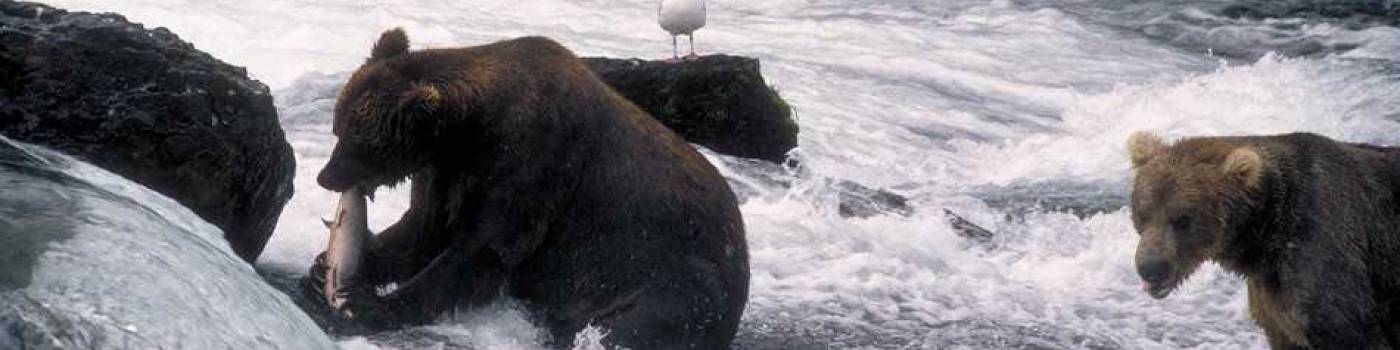
Most visitors pass through King Salmon on their way to Katmai National Park and Preserve, which is known for its giant grizzlies and the moon-like landscape of the Valley of 10,000 Smokes, a post-volcanic landscape created after the eruption of Novarupta in 1912. In the midst of this vast, 4.2-million acre park, a great deal of activity centers at Brooks Camp, which is the base for both bear viewing and bus tours to the Valley of 10,000 Smokes, which are led daily by National Park Service ranger/naturalists. Bear viewing takes place near Brooks Camp along the Brooks River and Brooks River Falls, where grizzlies gather by the dozen during salmon runs to fish and feast. Carefully managed viewing platforms and boardwalks allow visitors to safely experience this natural wonder. The outstanding fishing at Brooks Camp and at wilderness fishing lodges scattered throughout the park also attracts sport anglers from around the world.
King Salmon also offers access to numerous fly-in fishing and adventure camps and lodges on the Alaska Peninsula as well as wildlife viewing expeditions in Becharof National Wildlife Refuge, Alaska Peninsula National Wildlife Refuge and McNeil River State Game Sanctuary. Information about all the parks is available at the King Salmon Visitor Center, which is staffed by both the National Park Service and U.S. Fish & Wildlife Service. Other than the parks, the most interesting tour in the area is by road to the village of Naknek, the site of the world’s largest sockeye salmon run from mid-June to the end of July.
MCGRATH
McGrath is a small rural community that sits equidistance from Anchorage and Fairbanks where Interior Alaska meets Southwest Alaska. Not connected to the Alaska road system, the community enjoys a quiet, wilderness lifestyle with occasional bursts of activity brought by major sporting events in the winter.
ABOUT MCGRATH
Originally a seasonal Athabascan village, McGrath became a permanent settlement in 1904. McGrath enjoyed its heyday from 1911 to 1920 after gold was discovered at Ganes Creek and in the Ophir gold districts. Since the town is the northernmost point on the Kuskokwim River accessible by large riverboats, McGrath quickly became the regional supply center. The Iditarod Trail, which passes through McGrath, also boosted its growth as hundreds of miners walked and mushed over the trail on their way to the gold fields until 1925.
THINGS TO DO
McGrath comes alive each March when the community serves as one of 26 checkpoints during the Iditarod Trail Sled Dog Race. In Alaska’s most popular sporting event, more than 50 mushers race 16-dog teams along a 1,100-mile route from Wasilla to Nome, stopping over in McGrath and other checkpoints along the route. The trail is also the scene of the famous Iron Dog snowmobile race and the Iditarod Trail Invitational, a human-powered race that ends in McGrath and has been called “the world's toughest winter endurance race.”
In summer, visitors to McGrath use it as an access point to the southern unit of the Innoko National Wildlife Refuge. The 4.6-million-acre refuge was established to protect the vast Interior wetlands that are crucial for waterfowl nesting, resting, staging and molting. Most visitors explore the area by floating down the Innoko, Iditarod or Dishna rivers. Refuge headquarters are located in McGrath and are a good source of information about location conditions.
NAKNEK
Located at the northeast side of Bristol Bay in Southwest Alaska and home to the world’s richest sockeye salmon fishery, the community of Naknek is all about fishing.
ABOUT NAKNEK
Given its location, it’s no surprise that six salmon processors operate in Naknek, a village of a few hundred residents whose population swells with seasonal fish processing workers each summer.
Accessible by road from nearby King Salmon, Naknek sits on the north bank of the Naknek River. The village comes alive during the red salmon run from mid-June to the end of July. Almost 70 percent of the world’s sockeye salmon is caught in Bristol Bay and Naknek is in the heart of it with 20 million fish passing through. Thousands of people flood the area during the fishing season, sending millions of pounds of salmon down the road to King Salmon, where jets whisk away the fresh fish to restaurants and markets across the country.
The abundance of salmon attracted Yup'ik Eskimos and Athabascan Indians to the region more than 6,000 years ago and Russians traders by 1821. The first salmon cannery opened on the Naknek River in 1890 and by 1900, there were 12 canneries in Bristol Bay.
THINGS TO DO
The excellent fishing near Naknek isn’t just for commercial operators – several high-end fishing lodges offer guests the opportunity to fish for some of the pink, king, silver and sockeye salmon as well as fly fish for rainbow trout, Arctic Char and grayling. Most of these lodges are all-inclusive and provide guides to help you get to the very best fishing holes for the time of year you’re there.
In town, the Russian Orthodox St. John the Baptist Chapel in Naknek, reportedly constructed in 1886, is on the National Register of Historic Places. Naknek is also home to the Bristol Bay Historical Museum, which features archaeology, history and Native culture and documents Naknek's history as one of the largest commercial salmon fishing and canning headquarters in the world. The museum building is the original Fisherman's Hall, an early meeting place for fishermen.
PORT ALSWORTH
The spectacular scenery surrounding Port Alsworth is quintessential Alaska: tundra-covered hills, an array of mountains, glaciers, coastline, the largest lakes in the state and two active volcanoes.
ABOUT PORT ALSWORTH
Port Alsworth is community of 125 residents, located on the east shore of Lake Clark about 100 miles southwest of Anchorage. It is the only community within the vast wilderness of Lake Clark National Park and Preserve, which makes Port Alsworth a major gateway for adventurous souls seeking a wilderness experience in the national park.
The centerpiece of the area is spectacular Lake Clark, a 42-mile-long turquoise body of water hemmed in by mountains. But the national park is also where the Alaska Range merges into the Aleutian Range to form the Chigmit Mountains and is home to Mount Iliamna, at 10,016 feet, and Mount Redoubt, at 10,197 feet.
THINGS TO DO
Visitors who head into the vast wilderness of the national park are often a mix of anglers, river runners and experienced backpackers. There are no roads and few trails in the park but there are three federally designated National Wild and Scenic Rivers, which are popular with rafters and paddlers in inflatable canoes and kayaks. The park's watershed is one of the world's most important producers of Bristol Bay sockeye salmon, contributing a third of the annual harvest, and anglers arrive from around the world to hook a hard-fighting sockeye. Lake Clark also has a scattering of remote, isolated lodges, most accessible from Port Alsworth, where you can truly escape into a pristine wilderness for a few days without having to sleep on the ground.
Port Alsworth has lodging, raft rentals and other visitor services as well as a National Park Ranger Station with displays and videos on the park and a limited selection of maps and books for sale. A foot trail, one of the few maintained trails in the park, heads 2.5 miles from the village to serene Tanalian Falls.
DILLINGHAM
Dillingham is a full-service community that welcomes both the commercial fishing industry and a sizeable number of summer visitors in search of some of Alaska’s best sportfishing and wildlife viewing.
ABOUT DILLINGHAM
Dillingham is home to 2,347 residents, who live on the edge of the largest state park in the country, Wood-Tikchik State Park, and enjoy some of the best sportfishing in the entire state – which is saying something! All five species of Pacific salmon along with freshwater rainbow trout, arctic char and Dolly Varden are abundant in the Wood and Tikchik systems of lakes and rivers.
Strategically situated at the head of Nushagak Bay and along the mouth of the Wood and Nushagak rivers, Dillingham has become the economic and transportation hub of western Bristol Bay. Thanks to the rich fisheries of Bristol Bay, Dillingham is the fastest growing community in the region, supporting 230 commercial fishing licenses and four fish processing plants whose workers double the city’s population in the summer.
THINGS TO DO
Dillingham and the many surrounding wilderness areas are popular with outdoorspeople who want to enjoy remote wilderness, sportfishing, solitary lakes and quiet rivers and unparalleled wildlife viewing.
Wood-Tikchik State Park is spread over 1.6 million acres and named for its two separate systems of large, interconnected clear-water lakes. Bordered by the Nushagak lowlands on the east and the Wood River Mountains to the west, the two systems of lakes span a variety of terrain and are renowned for their diverse beauty. Other than a handful of fishing and hunting lodges in and around the park, Wood-Tikchik is an undeveloped wilderness that attracts kayakers, canoers, rafters and boaters. Visitors are usually totally self-sufficient and reach the park by air taxi from Dillingham or charter boat from the village of Aleknagik on Lake Aleknagik, 25 miles north of Dillingham and connected to the city by road.
Walrus Islands State Game Sanctuary is another popular spot near Dillingham. The sanctuary is made up of a group of seven craggy islands and their adjacent waters located in northern Bristol Bay southwest of Dillingham. Best know among the Walrus Islands is Round Island, the largest walrus haul-out grounds in Alaska, where each summer 15,000 male walruses haul out on exposed, rocky beaches to stake out their territory for the upcoming mating season. Other wildlife is also plentiful in the sanctuary, including Steller sea lions, migrating whales, orcas, puffins and thousands of other seabirds. Camping is available on Round Island, but the number of campers is limited to ensure the walruses are not disturbed, so make arrangements first with the Alaska Department of Fish and Game.
Dillingham is also the hub for many of the air taxis that operate within Togiak National Wildlife Refuge. The 4.7-million-acre refuge features pristine rivers, clear mountain lakes and steep sloped mountains and stretches from the Bering Sea to the treeless tundra uplands of the Ahklun and Wood River mountains. The main activities in the refuge are float trips and sport fishing. The refuge offers some of the finest salmon and trout fishing in Alaska; all five species of Pacific salmon can be found there. The refuge also provides habitat for at least 201 staging, migrating or breeding bird species while brown bear, moose and caribou attract sport hunters to the area. Along the refuge’s coastline, up to 12,000 male walruses may haul out on Cape Pierce at one time.
KODIAK
The city of Kodiak sits on Kodiak Island, which at 3,670 square miles and more than 100 miles long is Alaska's largest island and the second-largest island in the United States. Known as the Emerald Isle, Kodiak’s verdant landscape and abundant outdoor opportunities make it a popular choice for nature enthusiasts.
ABOUT KODIAK
The pulse of Kodiak beats along the waterfront and in its boat harbors: Alaska Marine Highway ferries dock right downtown, next to the Kodiak Island Visitor Center. Nearby is St. Paul Boat Harbor, the city’s largest. More boats dock across the channel at St. Herman Harbor on Near Island, and an afternoon on the docks can lead to friendly encounters with fishermen and the chance to see them unload their catch or repairing their nets.
Once a struggling fishing port, World War II turned the island of Kodiak into a major staging area for North Pacific operations. At one point Kodiak's population topped 25,000, with Fort Abercrombie built as a defense post to protect the naval base that was constructed in 1939. Today the old naval base is the site of the largest Coast Guard base in the country.
Kodiak’s famed cloudy weather spared it from a Japanese attack during WWII but the city wasn’t so lucky during the Good Friday Earthquake of 1964, which leveled its downtown area and wiped out its fishing fleet. Today Kodiak is among the top three fishing ports in the country and home to 650 boats, including the state's largest trawl, long-line and crab vessels, and 12 shore-based processors.
THINGS TO DO
More than 100 miles of paved and gravel roads head from the city into the wilderness that surrounds Kodiak. Some of the roads are rough jeep tracks, manageable only by four-wheel drive vehicles, but many can be driven to isolated stretches of beach, great fishing spots, outstanding coastal scenery and secluded campgrounds.
The island’s best-known park is the Kodiak National Wildlife Refuge. The 2,812-square-mile refuge encompasses two-thirds of Kodiak Island and includes a diverse habitat that ranges from rugged mountains and alpine meadows to wetlands, spruce forest and grassland. The refuge has outstanding fishing but the most popular activity is bear viewing. The refuge is home to 3,500 bears with males that normally weigh in at more than 800 pounds but have been known to exceed 1,500 pounds and stand more than 10 feet tall. The refuge has no roads, so bear viewing is done as a day tour with an air charter operator or as an excursion from one of many remote wilderness lodges on the island.
Kodiak is a renowned fishing destination that offers access to all five species of salmon along with halibut, rockfish, cod and trout.
Fort Abercrombie State Historical Park is a popular spot for learning more about the island’s World War II history. The fort was built during the war, and along with a campground features the Kodiak Military History Museum, located inside the Ready Ammo bunker. The historic ruins of the WWII coastal defense installation couples with the steep surf-pounded cliffs, deep spruce forests, wildflower-laden meadows and a lake containing trout.
HISTORY
Native Alutiiq people have inhabited the Kodiak area for more than 7,000 years. In the mid 1700s, the island was discovered by a Russian explorer, ushering in the island’s Russian period. Kodiak was the first capital of Russian-controlled Alaska, and was an important location in the lucrative fur trade. A former storehouse of fur pelts owned by the Russian American Company in downtown Kodiak now houses the Baranov Museum, which is a great place to learn more about the area’s history. The building, constructed in 1808, is the oldest standing building in the state of Alaska.
PORT LIONS
Port Lions is located in Settlers Cove at the north end of Kodiak Island, and like many small island villages in the Kodiak Archipelago, it’s an excellent place for wildlife viewing, birding, fishing and more.
ABOUT PORT LIONS
Port Lions was created after the tsunami from the Good Friday Earthquake destroyed the village of Afognak on Afognak Island to the north. Lions Club International assisted greatly in building the new community and relocating Afognak residents who eventually named their village in honor of the service group.
THINGS TO DO
Within town, a causeway provides foot and bike access across Settler’s Cove while charter boat services offer access into the nearby coves and bays for wildlife viewing. Throughout the summer, the waters around Port Lions are an excellent place to spot whales, including humpbacks, fin whales and orcas as well as sea otters, sea lions and seals. At the right time of year, birders can easily spot hundreds of puffins, eagles and kittiwakes in the area.
Most visitors arrive at Port Lions to cast a line into the bountiful waters that surround it. The sheltered bays between Kodiak, Afognak and Raspberry islands are home to some of the richest fisheries in Alaska. In May and June, trophy king salmon can be caught in the bays and in August, silver salmon begin to appear. Halibut, some topping 300 pounds, can be hooked almost anytime from May through September. Fishing excursions in July often result in a mixed bag of kings, silvers and halibut. Nearby streams and rivers are also very productive with sockeye salmon in June, pink salmon and Dolly Varden in July and silver salmon in August.
LARSEN BAY
Perched deep inside Uyak Bay, a narrow fjord 60 miles southwest of the city of Kodiak, Larsen Bay boasts a scenic location next to some of the best fishing grounds in the Kodiak Archipeligo.
ABOUT LARSEN BAY
Named for Peter Larsen, an Unga Island furrier, hunter and guide, the community is called Uyak by the Aleut people who have resided here for 2,000 years. The village drew national attention in 1991 when the Smithsonian Institution returned the remains of 756 Alutiiq Natives. Interred in a mass grave, the burial marked the largest repatriation of Native remains ever conducted by the Smithsonian. Like many Kodiak Island communities, the Russian influence of fur traders in the late 1700s and early 1800s can also be seen throughout Larsen Bay in Russian Orthodox churches and cemeteries.
THINGS TO DO
Larsen Bay is surrounded by Kodiak National Wildlife Refuge, the 2,812-square-mile preserve that covers two-thirds of Kodiak Island. The refuge's diverse habitat ranges from rugged mountains and alpine meadows to wetlands, spruce forest and grassland. Wildlife viewing is excellent in the refuge, and its most famous resident is the giant Kodiak brown bear. Lesser known but equally interesting is the birding – the refuge is home to more than 200 different species and 600 breeding pairs of bald eagles. Marine life is also plentiful, including seals, sea lions, porpoises, sea otters, whales and puffins. No roads enter the refuge, and no maintained trails lie within it, so the best way to view wildlife within the refuge is by chartered boat or plane.
Wildlife viewing aside, fishing is the main interest of most visitors to Larsen Bay. Excellent fishing lodges maintain a charter fleet that provides saltwater fishing opportunities within the protected bays and inlets near the village or on the open ocean for salmon, halibut, lingcod and rockfish. Rafts or even floatplanes are utilized for stream fishing for salmon, steelhead and Dolly Varden. Among the nearby stream fisheries is the Karluk River, world famous for its sockeye salmon and king salmon runs.
OLD HARBOR
Seventy miles southwest of the city of Kodiak on Kodiak Island and tucked away in the sheltered waters of Sitkalidak Strait is Old Harbor, a lively little port for commercial and sport fishing activity.
ABOUT OLD HARBOR
One of the most picturesque villages on Kodiak Island, the community of 193 residents is nestled on a narrow beach at the foot of a lush, green mountain while more dramatic peaks tower overhead to the northeast. Standing tall in the center of Old Harbor is Three Saints Russian Orthodox Church, the link to its rich past and the hub of community activity today. Three Saints Bay became the first Russian colony in Alaska but within four years a tsunami destroyed the settlement. Two more earthquakes struck before 1792 and the following year, Alexander Baranov moved the trading post northeast to St. Paul Harbor, now known as Kodiak. A settlement was reestablished at Three Saints Harbor in 1884 and the Old Harbor post office was opened in 1931.
The Alutiiq people had already lived in the area for more than 7,000 years when the Russians first landed on Kodiak Island in 1763. The abundance of sea otters attracted the attention of Siberian fur trader Grigorii Shelikhov, arrived in nearby Three Saints Bay in 1784 with 192 men and a cache of muskets and cannons. Shelikov’s attempts to “subdue” the indigenous people resulted in a bloodbath in which more than 500 Alutiiq were massacred and an equal number drowned in an effort to escape.
THINGS TO DO
Old Harbor is home to both fishing lodges and charter boat operators who target king salmon in May and silver salmon in September, often producing the winning fish in local salmon derbies. Charter captains often offer custom hunting, kayaking and wildlife adventures as well. The area is an excellent destination for viewing large sea mammal haul-outs and the archipelago's largest puffin colony, located on nearby Flat Island.
KARLUK
Located on what is thought to be the best sockeye (red) salmon river in the world and adjacent to the Kodiak National Wildlife Refuge on Kodiak Island, the Alutiiq village of Karluk is an outdoorsperson’s paradise.
ABOUT KARLUK
Karluk is located in a dramatic setting overlooking the mouth of the Karluk River and Shelikof Strait and surrounded by the Kodiak National Wildlife Refuge. A community of just a few dozen people and one of only two villages on the west side of Kodiak Island, Karluk is an ideal entry point into the refuge where anglers can easily access some of the best salmon fishing in Alaska.
Archaeologists believe the Karluk River has supported the subsistence fishing of local Alutiiq Natives for more than 7,000 years. The rich runs of salmon led Russian traders to establish a trading post on Karluk Lagoon in 1786 and within a few years, tanneries, salteries and canneries were being built in the area.
THINGS TO DO
Known for being the greatest sockeye salmon river in the world, the Karluk River also supports king salmon, Dolly Varden, steelhead and rainbow trout fisheries. A few miles inland, Karluk Lake also has spectacular fishing.
Most visitors pass through Karluk on the way to fishing lodges or other adventures in the adjacent Kodiak National Wildlife Refuge. The refuge, which covers two-thirds of Kodiak Island, is renowned for its fishing and opportunities to view the legendary Kodiak brown bear. Males average around 800 pounds, but have been known to exceed 1,500 pounds. Approximately 2,300 are found within the boundaries of the Kodiak National Wildlife Refuge. Approximately 180 to 200 of these bears use the 236 mile square Karluk Lake drainage, one of the densest populations of bears in the world.
Karluk is a photographer’s delight. The influence of the Russian traders can still be seen at the Ascension of Our Lord Russian Orthodox Chapel, built in 1888, and designated as a national historic site. The church features an unusual half-onion dome, typically seen in Russian architecture, and a spectacular cliff-and-ocean backdrop.
OUZINKIE
Ouzinkie is located on the southwest shore of Spruce Island, 10 miles north of the city of Kodiak on Kodiak Island, and is characterized by swampy areas, volcanic and sedimentary rock and an abundance of tall spruce trees.
ABOUT OUZINKIE
One of the oldest settlements of the archipelago, Ouzinkie is separated from Kodiak Island by a strait named Uskiy, which means “very narrow” in Russian. The Russian American Company founded Ouzinkie as a retirement community in the early 1800s. In the late 1800s, several canneries sprang up, reliant on the rich fishing grounds in the area. A series of disasters over the years including fire and a tsunami destroyed the canneries and were never replaced.
The Russian Orthodox Church of the Nativity, built in 1898, is tucked in a cove of spruce trees. The unique and picturesque Russian Orthodox architecture make it a favorite among photographers. Ouzinkie was home to St. Herman, the first canonized Russian Orthodox saint in North America. St. Herman's chapel is located at Monks Lagoon and can be explored with the local Russian Orthodox Church reader who explains the history of the holy sites and old gravestones. Every year in early August there is an annual pilgrimage to St. Herman’s home site on Spruce Island.
THINGS TO DO
Salmon and halibut fishing, beautiful scenery, wildlife, Native culture, Russian history and the view from the top of Mount St. Herman make Ouzinkie a perfect experience for the adventurous traveler.